Stairway to the Past: The Marine Terraces of the Mendocino Coast
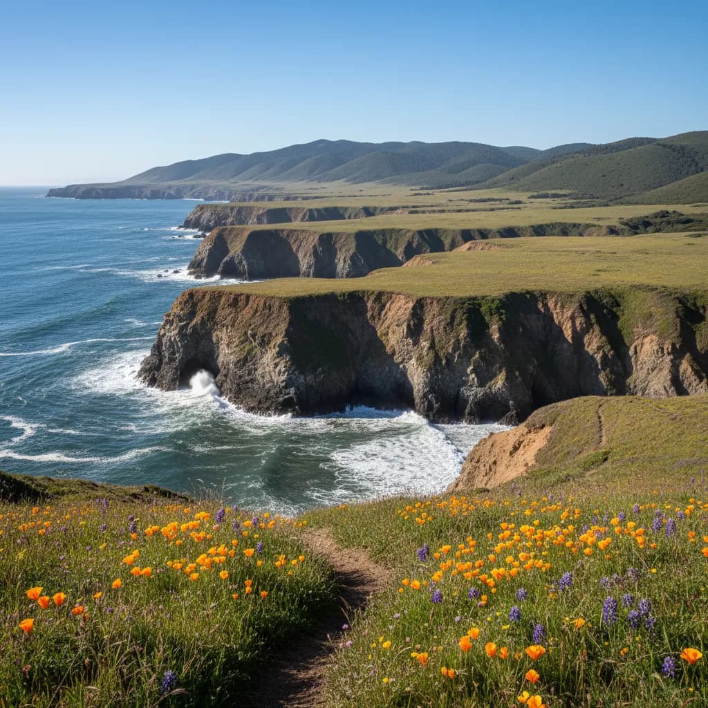
The Mendocino Coast's dramatic landscape rises from the Pacific in a series of giant steps, each one a chapter in Earth's geological history written in stone and soil.
These marine terraces, uplifted over millennia by powerful tectonic forces, create the distinctive stair step topography that defines the region's character.
Long before European settlement, Pomo and Yuki peoples recognized these coastal plateaus as abundant hunting and gathering grounds, where the meeting of land and sea provided exceptional resources.
Today, visitors walking across these ancient seafloors discover they're standing on landscapes that were once submerged beneath Pacific waves, lifted slowly skyward by the same forces that continue to reshape California's coast.
The Geological Architecture of Time
The marine terraces visible throughout the Mendocino Coast represent one of the most spectacular examples of coastal geomorphology in North America.
These flat or gently sloping platforms, separated by steep slopes or cliffs, formed during periods when sea levels stood higher than today.
Wave action carved flat benches into the coastal bedrock during these high stands, creating the platforms visitors now walk upon.
The mechanism behind this dramatic landscape lies deep beneath the coast at the Mendocino Triple Junction, located approximately 100 miles offshore near Cape Mendocino.
This unique geological feature marks the meeting point of three tectonic plates: the Pacific Plate, the North American Plate, and the Gorda Plate.
The intense pressure generated where these massive crustal sections converge drives the tectonic uplift that has been raising the Mendocino Coast at a rate of approximately one to four millimeters per year for the past several hundred thousand years.
This uplift rate may seem insignificant, but over geological time it produces dramatic results.
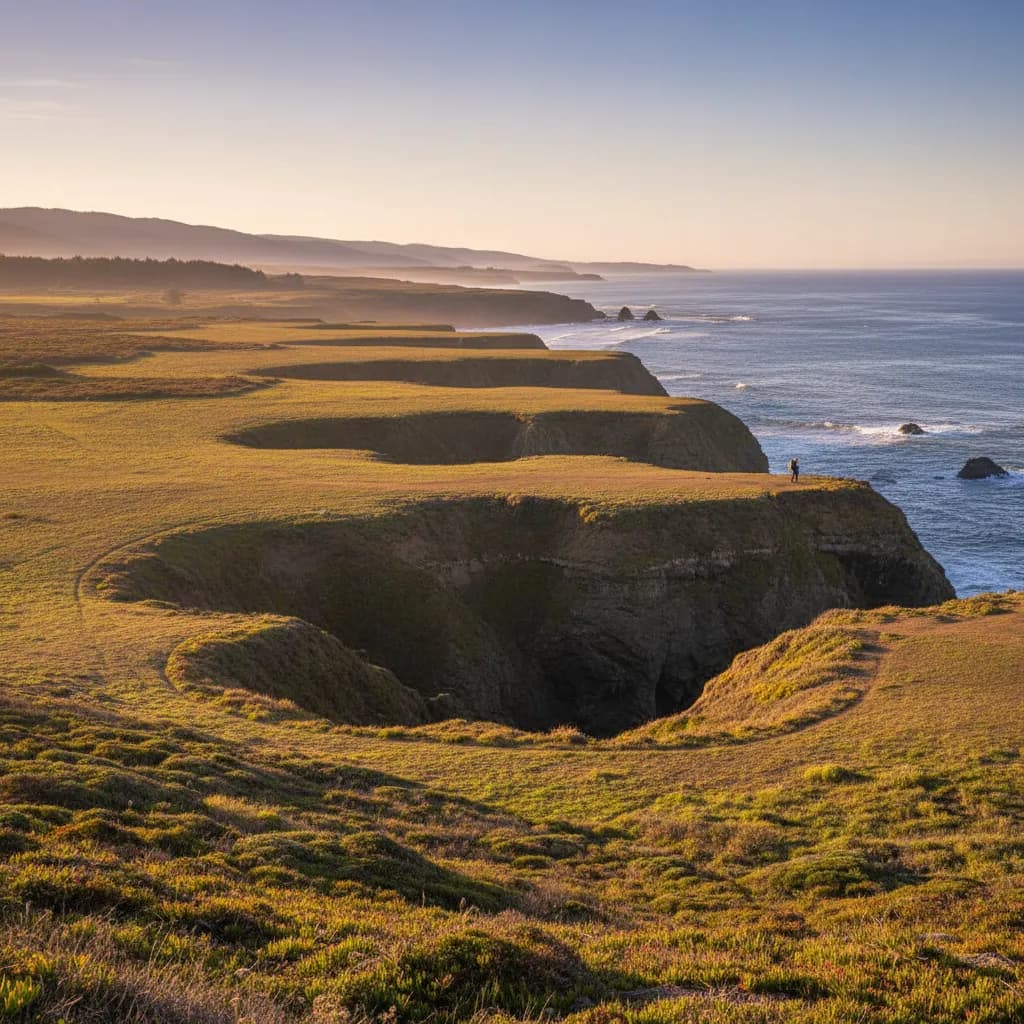
The highest marine terraces visible along the coast stand more than 600 feet above current sea level, representing uplift spanning hundreds of thousands of years.
Each terrace level corresponds to an interglacial period when warmer global temperatures melted ice sheets and raised ocean levels, allowing waves to carve new platforms before renewed uplift carried them skyward.
Reading the Layers
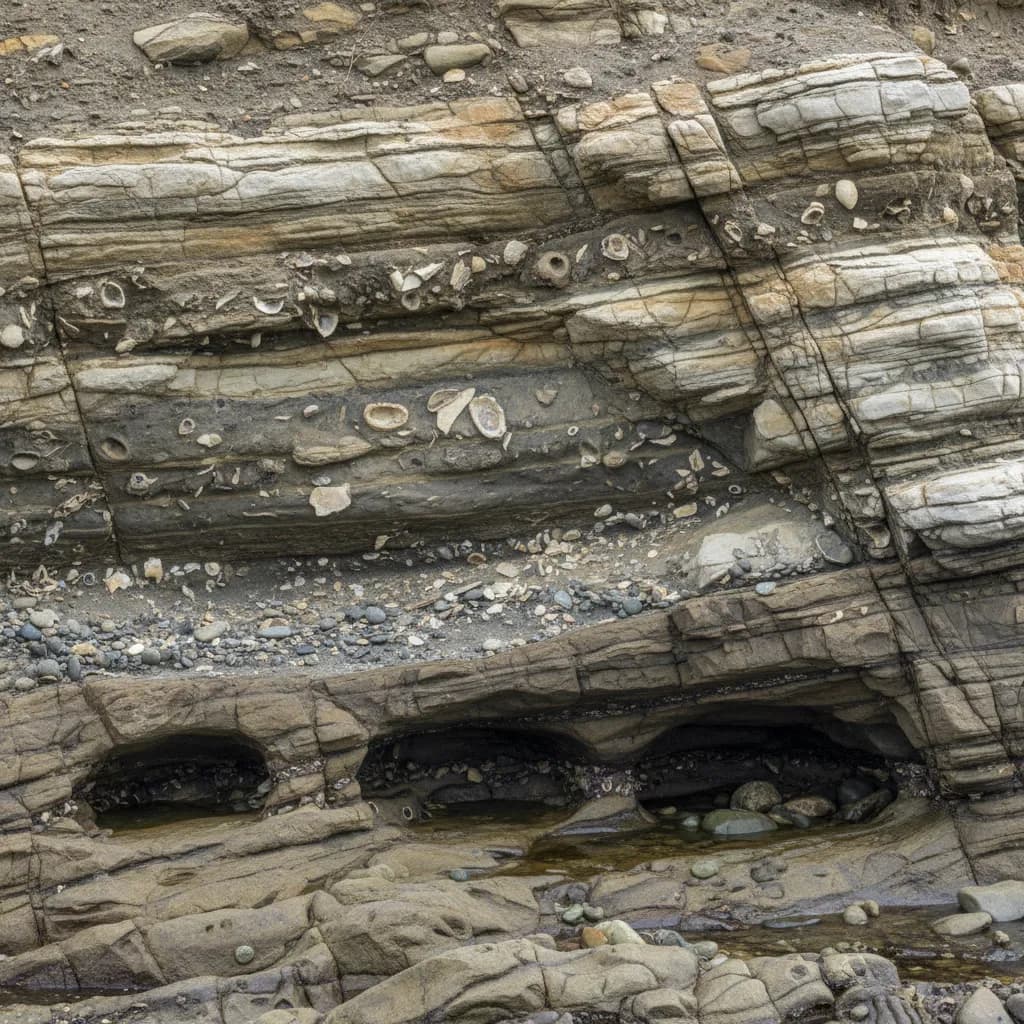
Geologists recognize at least five distinct terrace levels along the Mendocino Coast, though erosion has obscured some surfaces.
The lowest and youngest terraces, closest to the current shoreline, formed during the last interglacial period approximately 120,000 years ago when sea levels stood about 20 feet higher than today.
Higher terraces represent progressively older high sea level stands, creating a vertical timeline of sea level history and tectonic activity.
The Mendocino Headlands State Park provides exceptional opportunities to observe these features.
The flat grasslands visitors stroll across represent ancient wave cut platforms, while the dramatic cliffs dropping to today's ocean show where current wave action continues the eternal process of erosion and platform creation.
The park's famous blowholes and sea caves formed where wave action exploited weaknesses in the uplifted bedrock, creating natural sculptures that demonstrate ongoing coastal processes.
Cultural Landscapes Built on Ancient Shores
The Pomo and Yuki peoples who called this coast home for thousands of years developed intimate knowledge of these terraced landscapes.
The flat terrace surfaces provided travel routes and village sites, while the meeting zones between terrace levels created microclimates supporting diverse plant communities.
The spring fed wetlands that often form on terrace surfaces supplied fresh water and attracted game, making these uplifted platforms preferred settlement locations.
Archaeological evidence suggests indigenous communities recognized the geological distinctiveness of the region, incorporating coastal features into their cultural geography and seasonal movement patterns.
The rich marine resources accessible from terrace edges supplemented terrestrial hunting and gathering, creating the abundant lifestyle that supported substantial populations along this coast.
European settlement beginning in the 1850s similarly gravitated toward these flat terrace surfaces.
The lumber towns of Mendocino and Fort Bragg developed on marine terraces that provided level ground for mills, housing, and infrastructure while offering access to timber resources on the slopes above and shipping routes below.
The Italian, Portuguese, and Finnish immigrants who formed logging crews and fishing communities built their new lives on these ancient seafloors, often unaware they were constructing homes on platforms carved by Pacific waves hundreds of thousands of years earlier.
Fort Bragg's historic downtown, including landmarks like Mercato Bakery on Franklin Street, sits on one of these prominent terrace levels.
The bakery's location reflects the practical advantages that drew settlement to these flat coastal platforms, where Italian immigrant families later established businesses celebrating their heritage through authentic food traditions.
Exploring the Terraces Today
Visitors to the Mendocino Coast can experience marine terraces at numerous accessible locations.
Mendocino Headlands State Park offers the most dramatic and easily interpreted examples, with clear terrace edges, sea caves, and blowholes demonstrating both ancient and ongoing coastal processes.
The park's trail system provides free access year round from sunrise to sunset, with parking available in the town of Mendocino.
Russian Gulch State Park, located two miles north of Mendocino, showcases how streams cutting through uplifted terraces create dramatic coastal canyons.
The park's Devil's Punchbowl, a collapsed sea cave, illustrates how wave erosion works on uplifted bedrock.
Day use fees apply ($8 per vehicle as of 2024), with the park open daily from sunrise to sunset.
Seasonal Considerations
The September through November period offers ideal conditions for terrace exploration.
The clearest weather of the year during this "second summer" provides excellent visibility for appreciating the landscape's vertical structure and identifying different terrace levels.
Lower afternoon sun angles during autumn create dramatic shadows that emphasize the stair step topography, making geological features more visible than during summer's high sun.
Spring months bring wildflower displays to terrace grasslands, while winter storms demonstrate the wave power that carved these platforms.
Gray whale migration from December through May (peaking in March and April) adds marine wildlife viewing to geological exploration, as whales pass close to shore along the terrace edges.
Connecting Geology to Experience
Understanding the marine terraces transforms a simple coastal walk into time travel.
That flat meadow becomes an ancient beach.
Those cliffs represent the boundary between different geological epochs.
The soil beneath visitors' feet contains marine sediments deposited when Pacific waves washed over this exact spot, perhaps 200,000 years ago.
Van Damme State Park, five miles south of Mendocino, offers additional terrace exploration combined with access to old growth forests in the canyon below.
The park's Fern Canyon Trail descends through terrace levels into a lush canyon ecosystem, demonstrating how water erosion cuts through uplifted platforms.
Day use fees apply, with the park open sunrise to sunset.
Jug Handle State Natural Reserve, located north of Caspar, features an "ecological staircase" where five distinct terrace levels support progressively older and more nutrient depleted soils.
The reserve's interpretive trail explicitly connects geology to ecology, showing how tectonic uplift and soil development create distinct plant communities at different elevations.
This five mile trail offers perhaps the coast's most educational terrace experience, with free access during daylight hours.
Planning Your Terrace Exploration
Most marine terrace viewing requires only sturdy walking shoes and weather appropriate clothing.
Trails across terrace surfaces generally remain level and accessible, though edges often feature dramatic drops requiring caution.
Binoculars enhance the experience, allowing detailed observation of geological features and marine wildlife from safe distances.
The Mendocino Coast's ongoing tectonic uplift means visitors witness active geology.
Small earthquakes occur regularly as the Mendocino Triple Junction continues its work, though most remain imperceptible without instruments.
This living landscape offers perspective on geological time while demonstrating that Earth's surface remains dynamic and ever changing.
After exploring these ancient seafloors, many visitors return to Fort Bragg's downtown to reflect on deep time over authentic Italian coffee at Mercato Bakery, where conversations often turn to the remarkable forces that shaped the coast beneath their feet.
The marine terraces of the Mendocino Coast offer more than scenic beauty.
They provide tangible connection to Earth's deep history and ongoing transformation, inviting visitors to see the landscape not as static backdrop but as dynamic record of planetary processes spanning hundreds of thousands of years.
The Mendocino Coastal Chronicle documents the natural beauty, cultural heritage, and historical significance of the Mendocino Coast for visitors, students, and researchers. Our articles combine historical research, ecological science, and cultural appreciation to celebrate this unique region.
Educational Resources: For current visitor information, hours, and fees, please contact local visitor centers and state park offices. Conditions and regulations may change seasonally.
Indigenous Acknowledgment: The Mendocino Coast is the ancestral homeland of the Pomo and Yuki peoples, who have stewarded these lands for thousands of years. We honor their continuing connection to this place.
Published by the Mendocino Coastal Chronicle | Educational content for the appreciation and understanding of California's North Coast heritage.